


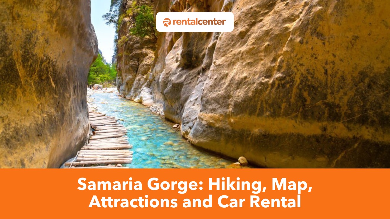
Samaria Gorge: Hiking, Open Hours, Map, Attractions and Car Rental Guide
Samaria Gorge is one of Crete’s most iconic natural wonders, drawing hikers globally to experience its rugged beauty, rich history, and ecological significance. The gorge stretches 16 kilometers (9.9 miles) through the White Mountains in southwest Crete, and descends from the Omalos Plateau to the Libyan Sea at Agia Roumeli.
Samaria Gorge is an UNESCO Biosphere Reserve and is home to rare species like the kri-kri goat and golden eagle, and it holds ancient ruins such as the city of Tarra. The main hiking route begins at Xyloskalo and takes 5-7 hours to complete, with notable landmarks including the abandoned village of Samaria and the narrow “Iron Gates”. Samaria Gorge hike is moderately challenging, although shorter alternatives exist for those seeking a less strenuous trek.
The best time to visit Samaria Gorge is May to June or September to October, when temperatures are mild and crowds are thinner. Preparation is essential, and hikers should bring water, sun protection, snacks, and supportive footwear. Nearby attractions include the Omalos Plateau and the surrounding Lefka Ori mountains, with overnight stays available in both Omalos and Agia Roumeli.
Travelers can reach the trailhead by car, public bus, or guided tour, with Crete car rental offering the most flexibility. Visitors often enjoy traditional Cretan meals at tavernas near the trail’s entrance and exit after the hike. Samaria Gorge promises a memorable journey through one of Crete’s most breathtaking landscapes, whether for seasoned trekkers or curious travelers.
When will the gorge of Samaria open for 2025?
As of April 12, 2025, the official opening date for Samaria Gorge has not been confirmed. Traditionally, the gorge opens to visitors from May 1 to October 31, with daily visiting hours from 07:00 to 15:00. The exact opening date each year depends on weather conditions and the completion of necessary maintenance work.
What is Samaria Gorge?
Samaria Gorge is a 16-kilometer (9.9-mile) canyon located in southwest Crete, a natural formation carved by water and tectonic activity through the limestone of the White Mountains. The gorge starts at an altitude of 1,250 meters (4,101 feet) at Xyloskalo in the Omalos Plateau and descends to sea level at Agia Roumeli on the Libyan Sea.
The area has been inhabited since antiquity, with archaeological evidence of ancient settlements, including the ruins of the city of Tarra near the southern exit. Tarra was known for its temple of Apollo and served as an important religious and commercial center during the Classical and Hellenistic periods. The gorge’s steep cliffs and narrow passageways formed naturally over millions of years, shaped by the river Tarraios and geological shifts along fault lines.
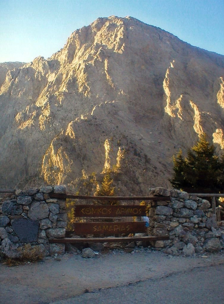
Samaria Gorge is part of the Samaria National Park, which was established in 1962 to protect its biodiversity and cultural heritage. It is designated a UNESCO Biosphere Reserve and supports species such as the endangered kri-kri (Cretan wild goat), golden eagles, and endemic plants. The gorge contributes significantly to Crete’s tourism industry, attracting thousands of hikers each year and supporting local economies in Omalos, Agia Roumeli, and nearby towns.
The economy of Samaria Gorge solely relies on tourism. Approximately 130,000 people per year have visited the Samaria gorge, since 1981. Activities are restricted within the national park. Tourist revenues from the numerous yearly visits to Samaria Gorge are a significant source of income for the local economy. The Samaria Gorge is a specially-protected area that is a very well-known tourist destination. For the last five years, the total number of visitors to the Samaria Gorge reached 744.288 according to the Chania Forest Directorate.
Samaria Gorge is managed by the Samaria National Park (White Mountains) Management Body and it operates under Greek laws (Law 3044/2002 and Law 2742/1999) and emphasizes state ownership, strict conservation rules, and technological tools like Geographic Information Systems (GIS) for monitoring vegetation, land use, and tourism. Logging has been banned since the 1960s. The gorge has received continuous international recognition, including the European Diploma for Protected Areas (since 1979) and designation as a UNESCO Biosphere Reserve highlighting its global ecological value and model of sustainable environmental governance.
What is the cost of entering Samaria Gorge?
Entrance to Samaria Gorge requires a paid ticket, available in four types. The individual daily ticket costs 5 €. Group tickets (for over 10 members) cost 4 € per person. Family tickets (for adults and children) cost 3 € per person. An annual personal pass costs 10 € and children udner 18. Tickets are sold at entry points or online.
Entry is free for children under 18, seniors over 65, EU students, large families, disabled individuals with their companions, military personnel, researchers, and local residents. Educational school or university trips and group hikes by the Hellenic Mountaineering Club of Chania are also exempt. Public free days include March 21, May 21, and June 5. Visitors can issue a ticket online at the following page https://samaria-tickets.necca.gov.gr/checkout
How difficult is hiking in Samaria Gorge?
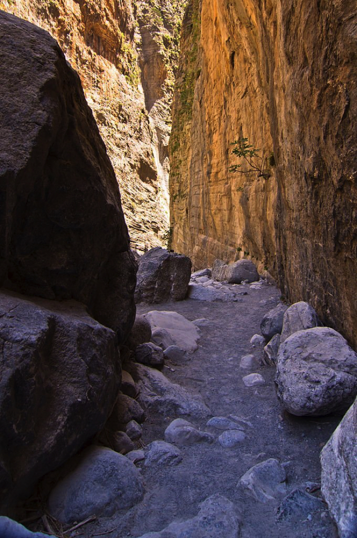
Hiking in Samaria Gorge is moderately challenging. The entire trail stretches 16 kilometers (9.9 miles) from the entry point at Xyloskalo to the exit at Agia Roumeli, descending over 1,200 meters (3,937 feet) in elevation. The path is rocky, uneven, and often steep, with loose stones that increase the risk of slips, twisted ankles, and fatigue.
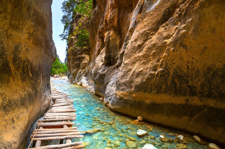
The most challenging sections include long downhill slopes, narrow cliffside passages, and the 3-meter-wide “Iron Gates”, where the gorge walls rise vertically to 300 meters (984 feet). No guide is required to complete the hike, and most visitors walk the trail independently, although licensed hiking guides are available for hire from Chania or organized tours, and they assist with navigation, pacing, and emergencies. Elderly people with strong fitness levels and hiking experience may complete the trail, but it is not recommended for people with mobility issues or heart conditions. Couples often hike together without issue, especially when well-prepared with water, proper footwear, and sun protection. The route is not considered child-friendly due to its length, lack of shortcuts, and the physical demands of the descent, especially in the summer heat.
An average walk takes 6 to 7 hours to hike the Samaria Gorge. The hike will normally include some stops. The main path is 13 kilometres (8,08 miles), and the path is quite rocky. Visitors will need to cross rivers several times. There are recreational points inside the Samaria Gorge where visitors can rest while enjoying the lovely scenery.
A guide is not needed but it is recommended to hike the Samaria Gorge. Hiking is one activity that needs physical endurance. A guide is important in hiking the Samaria gorge because it makes the whole hiking easier. Guides are the ones who navigate the trail and assist hikers with their needs. Visitors will need not worry about getting lost with the help of a guide. Visitors can book a guided tour in advance for an easier hike.
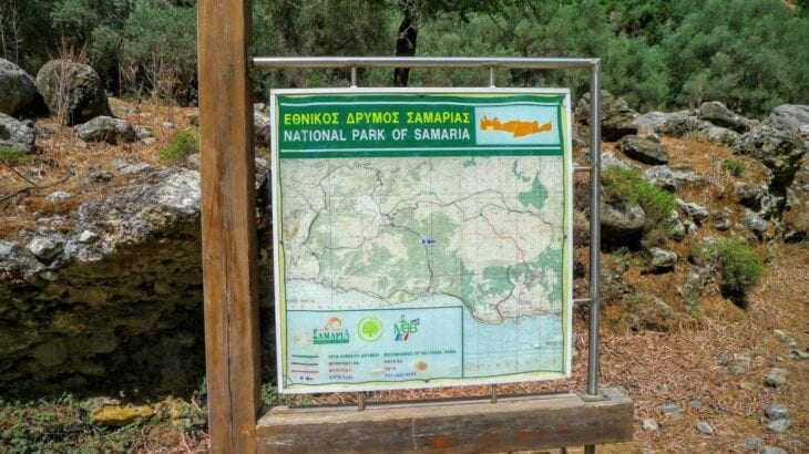
How does the Samaria Gorge map look?
Find below an image describing the map of Samaria Gorge.
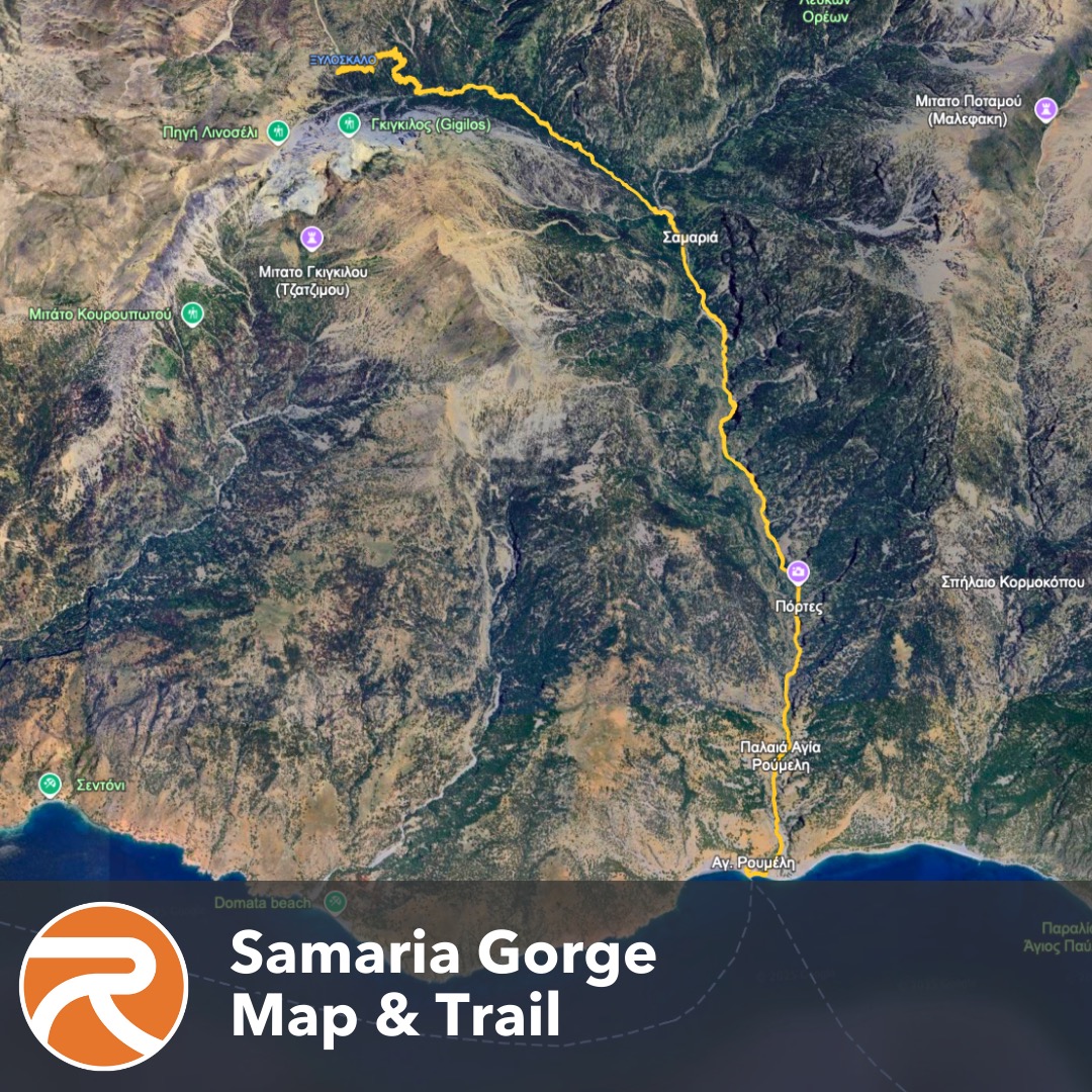
The Samaria Gorge map outlines a 16-kilometer (9.9-mile) trail that starts at Xyloskalo on the Omalos Plateau and goes southward to Agia Roumeli on the Libyan Sea. The path traverses varying terrains, including steep descents, rocky sections, and narrow passages. Key landmarks indicated on the map include the abandoned village of Samaria, located halfway through the gorge, and the “Iron Gates”, the narrowest point where the gorge tapers to about 4 meters wide with cliffs that stand up to 300 meters (984 feet) high.
The map also marks rest areas, water sources, and emergency exits along the route. Topographical features such as elevation changes are depicted, highlighting the descent from 1,250 meters (4,101 feet) at the entrance to sea level at the exit.
What are the hiking routes for Samaria Gorge?
Find below a list of the hiking routes for Samaria Gorge:
- Xyloskalo to Agia Roumeli. Xyloskalo to Agia Roumeli is the primary hiking route of Samaria Gorge. It begins at Xyloskalo, located at an altitude of 1,250 meters (4,101 feet) on the northern edge of the Omalos Plateau. The trail is 16-kilometer (9.9-mile) long and descends southward, concluding at Agia Roumeli by the Libyan Sea. Hikers navigate varying terrains, including steep descents, rocky paths, and narrow passages, notably the “Iron Gates”, where the gorge narrows to 4 meters (13 feet) wide with cliffs soaring up to 300 meters (984 feet) high. The trail also passes through the Samaria, an abandoned village offering insights into the area’s historical habitation. The trek normally takes around 5-7 hours to complete, depending on individual pace and rest stops.
- Agia Roumeli to the Iron Gates. Agia Roumeli to the Iron Gates is for trekkers seeking a less exhausting option. Hikers can choose the alternative path that begins at Agia Roumeli and leads to the “Iron Gates”, the gorge’s narrowest and most dramatic section. This out-and-back hike covers 4 kilometers (2.5 miles) round trip and allows hikers to experience the impressive scenery sans undertaking the full descent. The path is relatively flat compared to the full trail but still features rocky terrain. This option is suitable for individuals with limited time or adventurers who prefer a less demanding hike while still enjoying the natural beauty of one of the most renowned Crete gorges.
- Xyloskalo to the Abandoned Village of Samaria. Trekkers can also hike from the trailhead at Xyloskalo down to Samaria, located 8.2 kilometers (5.1 miles) into the gorge. This route allows hikers to experience the initial steep descent and witness significant landmarks, including the old village structures and surrounding natural beauty. This hike is moderately challenging and offers a peek into the gorge’s history and ecology without committing to the full length of the trail.
When is the best time to visit Samaria Gorge?
The best time to visit Samaria Gorge is May to early June and mid-September to October. These months provide predictable weather, modest crowds, and reasonable trekking conditions. Daytime temperatures during these seasons range from 24°C to 30°C (75°F to 86°F), making the trail easier to complete without being too hot or chilly. Samaria Gorge is officially open to hikers from May to October, subject to weather conditions and upkeep.
Temperatures in Samaria Gorge frequently soar beyond 35°C (95°F) in July and August, creating more strenuous conditions along the trail, especially in exposed areas with minimal shade. The route is closed throughout the winter owing to rain, rockfall, and water from the canyon’s riverbed. Hikers planning a visit in the spring may meet running water and blossoming foliage, whereas fall visitors enjoy cooler temperatures and fewer tourists.
What are the things to bring when visiting Samaria Gorge?
Find below a list of things to bring when visiting Samaria Gorge:
- Sturdy hiking boots. Sturdy hiking boots support the ankles and provide traction on the rocky and uneven terrain throughout the gorge. The trail includes loose stones and long descents that increase the risk of slips for hikers wearing improper footwear.
- Backpack. A lightweight backpack allows hikers to carry essentials such as water, food, and personal items without adding unnecessary weight. A well-fitted pack with padded straps prevents shoulder strain during the 5 to 7-hour walk.
- Water. At least 2-3 liters of water per person is necessary, especially in warmer months when dehydration is a serious risk. There are a few water refill points along the trail, but it’s safer for trekkers to carry their own supply from the start.
- Food and snacks. High-energy snacks such as nuts, dried fruits, and sandwiches help maintain energy and prevent fatigue along the way. There are no food vendors inside the gorge, so hikers must be self-sufficient for the full duration.
- Sun protection. Sunscreen, a wide-brimmed hat, and sunglasses shield hikers from direct sunlight, particularly in exposed sections of the trail. Prolonged sun exposure can lead to sunburn or heat exhaustion, especially in summer.
- Map or GPS. A physical map or GPS app helps track position and identify landmarks even though the route is well marked. It helps to know progress along the trail in rare cases of fog or large crowds.
- First-aid kit. A basic first-aid kit should include blister pads, antiseptic wipes, bandages, and any personal medications. The trail is remote and rocky, so even small injuries can become problematic without basic treatment.
- Trekking poles. Trekking poles improve stability on descents and reduce stress on the knees, particularly in the early steep section from Xyloskalo. They are especially useful for hikers with joint issues or poor balance.
- Light jacket or layers. A light jacket or extra layer is useful for the early morning start when temperatures are cooler at higher altitudes. The weather warms quickly during the descent, so layers help manage comfort throughout the day.
- Swimsuit and towel. A swimsuit and towel are useful for those who want to swim at Agia Roumeli after the hike. The beach at the exit offers a refreshing end to the long walk, especially during hot weather.
What are the nearby attractions in Samaria Gorge?
Find below a list of the nearby attractions in Samaria Gorge:
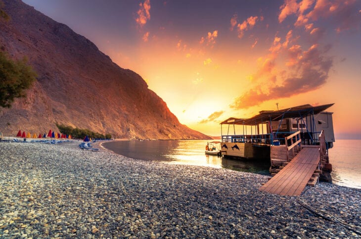
- Agia Roumeli. Agia Roumeli is a coastal village located at the southern exit of Samaria Gorge, accessible primarily by foot through the gorge or by ferry. This secluded village offers a relaxing beach along the Libyan Sea, where hikers often unwind after completing the trail. Agia Roumeli features traditional tavernas serving local Cretan cuisine and provides insight into the lifestyle of a village accessible only by sea or hiking.
- Omalos Plateau. Omalos Plateau is located near the northern entrance of Samaria Gorge at an altitude of approximately 1,200 meters (3,937 feet). This expansive plain is surrounded by the White Mountains, serving as a jump-off point for the hike through the gorge. The plateau is known for its scenic beauty, traditional shepherd huts, and offers opportunities for shorter walks and exploration of the alpine landscape.
- White Mountains (Lefka Ori). The White Mountains, or Lefka Ori, encompass the region around Samaria Gorge and are characterized by their limestone peaks, some exceeding 2,000 meters (6,562 feet). This mountain range offers numerous hiking trails of varying difficulty, leading to remote villages, high-altitude plateaus, and caves. Lefka Ori is rich in biodiversity, hosting endemic flora and fauna, and provides panoramic views of Crete’s diverse landscapes.
- Glyka Nera Beach. The beautiful beach of Glyka Nera is quite remote, and it takes a good hike to reach it. Glyka Nera is located on the southwestern coast of Crete, between the villages of Chora Sfakion and Loutro. The word Glyka Nera means “Sweetwater”, the name was derived from the clear freshwater that flows through the pebbles and into the sea.
- Kaino archaeological site. It is a small ancient city built inside the Samaria gorge. Kaino was developed in the ancient years. It was the birthplace of Artemis the Britomartia, named Diktini, who was Zeus’ daughter.
- Osia Maria Church. The Osia Maria church is a 14th century Byzantine church dedicated to Osia maria of Egypt. The name “Samaria” is a contraction of Osia and Maria. It is located on the southern side of Samaria Gorge.
- Mashali Beach. It is located on the west part of the bay of Agia Roumeli, a small village located south of Chania City, on a vast bay shaped at the exit of the Samaria gorge. Numerous visitors, descending the gorge, reach Mashali Beach and enjoy a bath. It is a quiet beach where visitors can explore and do some kayaking.
What are the transportation options to get to Samaria Gorge?
Find below a list of the transportation options to get to Samaria Gorge:
- By car rental from Chania. Driving from Chania to the trailhead at Xyloskalo on the Omalos Plateau is a popular option for independent travelers. The distance is 41.7 kilometers (25.9 miles) and the journey takes roughly 1 hour and 15 minutes via the mountainous VOAK and Omalos roads. Car hire in Chania is available through providers such as Rental Center Crete, with many travelers using this service to explore the region on their own schedule. The parking area at Xyloskalo is paved and can accommodate private vehicles, though it fills quickly during high season.
- By public bus. KTEL buses operate seasonal routes from Chania to Omalos, departing early in the morning to reach the trailhead before the park opens. These buses are scheduled to align with hiking times, and return services are coordinated with ferry arrivals at Sougia or Chora Sfakion. This option is suitable for visitors without a car and is widely used by solo hikers or budget-conscious travelers.
- By organized tour. Many travel agencies based in Chania and Rethymno offer full-day guided tours to Samaria Gorge. These packages include round-trip bus transport, park entry tickets, a licensed guide, and ferry transfers from Agia Roumeli to Sougia or Chora Sfakion. This option is convenient for those who prefer not to manage logistics, especially when navigating ferry schedules and bus timetables.
Can you use a Crete car rental to go to Samaria Gorge?
Yes, visitors can rent a car to go to Samaria Gorge. The drive to the trailhead at Xyloskalo follows a mountain road through the Omalos Plateau, covering 42 kilometers (26 miles) in about 1 hour. Parking is available at the entrance of the National Park, with designated lots charging a small fee. Spaces are limited during the summer season, so arriving early in the morning is advised.
Renting a car in Crete allows for greater flexibility, especially for hikers starting early or combining the trip with visits to nearby villages and viewpoints. A compact or mid-sized car is generally sufficient, as the roads to Omalos are paved and in good condition, though some travelers prefer a vehicle with extra power for uphill driving. Factors to consider before booking include transmission type, fuel policy, insurance coverage, and whether the company allows ferry transport if combining the rental with other destinations. A dependable Crete car rental makes it easy to reach Samaria Gorge on a customized schedule while avoiding the constraints of bus timetables and organized tours.
Crete is a gorgeous island with several tourist spots that can be travelled using a rented car. Crete car rental costs vary depending on the number of passengers, itinerary, car type, location, and duration. The average cost of renting a vehicle in Crete is around 30 € ($32.40, £25.80) to 40 € ($43.20, £34.40) per day. A car rented for a whole week will cost an average of 250 € ($270.00, £215.00). Renting a vehicle for the weekend will cost around 78 € ($84.24, £67.08). Affordable car rentals in Crete vary depending on the car type. Car rental companies offer a variety of cars depending on customers’ preferences.
Insurance coverage in Crete rentals includes Collision Damage Waiver. A credit or debit card in the driver’s name is required as a guarantee. Driver’s age must be at least 21. A valid driving licence issued at least 12 months earlier is necessary. Driver’s gender does not affect eligibility. Both men and women can legally drive in Crete from age 18. Some personal biases may still exist. Car type must match the travel needs. Larger vehicles suit groups or families. Smaller cars are recommended for Crete due to narrow roads. Documents required include a valid driving licence and a debit or credit card in the driver’s name.
What do visitors say about Samaria Gorge?
Visitors describe Samaria Gorge as a physically demanding yet rewarding hike, offering some of the most dramatic scenery in Crete. The experience is often praised for its length, diversity in terrain, and well-maintained path, though many caution that it is not a casual walk. Most hikers agree that the descent from Xyloskalo to Agia Roumeli, which spans roughly 16 kilometers (9.9 miles), places significant pressure on the knees and feet, especially over rocky ground and loose stones.
The scenery changes throughout the hike, from shaded pine forests to narrow rock corridors like the “Iron Gates”, and many highlight the sight of kri-kri goats and the cold, clean spring water available along the trail. Reviews recommend arriving early, wearing supportive footwear, and packing enough food and water for the day.
Organized tours help manage transportation and timing, particularly the coordinated ferry trip at Agia Roumeli. Several hikers emphasize that fitness and preparation are key, and the trail is not for visitors expecting a light or relaxing activity. Critical feedback focuses on the physical toll of the hike, the commercial nature of tour packages, and limited guidance from some tour leaders. A few visitors found the route crowded or underwhelming compared to other Crete gorges.
Samaria Gorge is often wrongly claimed to be 18 kilometers long. The actual gorge measures 16 kilometers; the extra distance includes the route from Omalos to Agia Roumeli. The claim that it is the longest gorge in Europe is false. France’s Gorges du Verdon is longer, measuring over 20 kilometers.
The belief that Samaria Gorge is always crowded is inaccurate. Hikers begin at different times, move mostly in one direction, and rarely encounter many others.
A local legend tells of Chrisomalousa, a noblewoman from Sfakia in 1319. Her rejection of a Venetian suitor led to violence. She became a nun at the Church of Maria Osia in the gorge. Restoration in the 1970s uncovered a grave with hair and a jewel, believed to be hers.
The ancient town of Keno is thought to have existed in the gorge. Myth says it was the birthplace of the goddess Vritomartis.
Greek mythology claims a Titan sliced the land to form the gorge. Zeus later chose Mount Gygilos above the gorge as his throne.
What are the places to stay overnight near Samaria Gorge?
Find below a list of the places to stay overnight near Samaria Gorge:
- Exari Hotel. Exari Hotel is located in Omalos, 1.5 kilometers (0.9 miles) from the Xyloskalo entrance of Samaria Gorge. The hotel offers traditionally styled rooms with wooden furnishings and mountain views. Visitors who want to sleep near the northern trailhead often choose Exari for its proximity and shuttle service to the gorge entrance.
- Omalos Hotel. Omalos Hotel is located in the Omalos Plateau region, 2 kilometers (1.2 miles) from the entrance to the gorge, ideal for hikers planning an early morning start. This family-run hotel features straightforward accommodations, an on-site restaurant serving Cretan cuisine, and a transfer service to the park.
- Calypso Hotel. Calypso Hotel is located in Agia Roumeli, directly at the gorge’s southern exit. The hotel provides air-conditioned rooms with private balconies and beach access. Hikers finishing the trail often stay here overnight to rest, swim, and enjoy a quiet evening before catching the ferry the following day.
- Sweet Corner Masxali. Sweet Corner Masxali is located just steps from the Libyan Sea in Agia Roumeli. This charming bed-and-breakfast offers traditional rooms with sea or mountain views, and a restaurant that serves homemade meals. Its beachfront setting and proximity to the gorge’s exit make it a popular choice for overnight stays after the hike.
What are the places to eat and drink near Samaria Gorge?
Find below a list of places to eat and drink near Samaria Gorge:
- Xyloskalo Café-Restaurant. Xyloskalo Café-Restaurant is located at the parking lot beside the Xyloskalo trailhead, making it the most accessible place to eat before starting the Samaria Gorge hike. The menu includes traditional Cretan dishes such as staka with eggs, grilled meats, and seasonal salads. Guests often highlight the fresh ingredients, reasonable prices, and homemade presentation. Coffee and beer are served in a relaxing setting with panoramic views over the gorge. The owner is known for being welcoming, and the café’s quiet atmosphere makes it a pleasant stop before or after hiking.
- Faragi Taverna. Faragi Taverna is located in Agia Roumeli, near the gorge’s southern exit and close to the ferry dock. This taverna is a popular choice for hikers looking to recover with a proper meal after the trail. The menu includes grilled meats, fish of the day, baked cheese, and local specialties like souvlaki and giant beans. Diners often mention the friendly service, generous hospitality, and post-meal offerings of watermelon and raki. Ice-cold beer served in frozen glasses is another standout for weary hikers arriving under the sun.
- Rousios Taverna. Rousios Taverna is located in Agia Roumeli and is well regarded for its hearty, authentic food and calming atmosphere. Highlights include goat in tomato sauce, lamb with potatoes, and house-made moussaka, all served in generous portions. The garden-fresh house salad and pizza receive consistent praise for their freshness and flavor. Many guests return to Rousios after swimming in the sea, appreciating the food quality, attentive service, and shaded terrace with a coastal view.
Published on April 12, 2025


